In 2022, the High Court of South Africa found that Searcher had failed to consult with small-scale fishers, indigenous communities, non-governmental organizations, and other relevant interested parties in obtaining their permit to conduct seismic blasting – called a reconnaissance permit – and stopped Searcher from continuing seismic surveys.
However, in late 2022, the then Department of Mineral Resources and Energy granted Searcher environmental authorisation for offshore seismic surveys off the coast of South Africa under reconnaissance permit 12/1/043, as this area was further from the shore. Searcher began their seismic survey operation in January 2024 but were unable to complete the planned survey. The current reconnaissance permit will expire on 10 November 2024. Searcher, therefore, applied for and received a new permit (12/1/048) over the same area. Searcher plans to begin its surveys in early 2025 if it receives the necessary environmental authorisation.
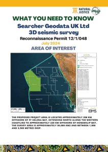
The proposed project area is located approximately 256 km offshore of St Helena Bay, extending north along the western coastline to approximately 220 km offshore of Hondeklip Bay. The survey area is approximately 30,000 km2 and between 1,000 and 3,500 metres deep.
This pamphlet was developed in July 2024 to provide communities with an understanding of the project and activities to date.
You can also access and download versions in Afrikaans and isiXhosa.

