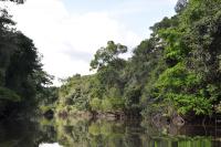
In a bid to protect over 1.4 million hectares of community land, the Wapichan community of Guyana have produced a digital map of their territories. The mapping project, carried out over the past ten years using GPS technology to plot key community sites, covers a diverse array of ecosystems and will support the community to establish the community’s rights to its land.
Kid James described the aim of the mapping, “once ownership rights are secured there is potential for economic benefit as there are some development actions, such as ecotourism and non-timber extractive reserves, identified for different parts of the area.” The map was finalised through multiple validation meetings with community members and communities who neighbour the Wapichan over five years.
Read more about the mapping process through Alert Net here and through the Forest Peoples Programme here.